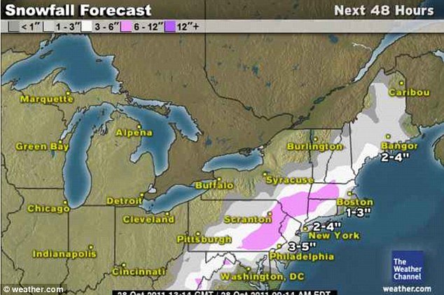
Forecasts for north eastern US have changed in the last couple of days and the prospect of a snow-free Halloween weekend have now gone.
October has been relatively mild so far but now north eastern states are suddenly braced for snow this weekend.
Low pressure will track up the East Coast on Saturday possibly bringing significant amounts of the white stuff across the tri-state area, Pennsylvania and New England.
New York has received measurable snow before Halloween only three times since 1869 – and never more than one inch, which is what some experts are predicting.
It would be the earliest one-inch snowfall in New York since the Civil War.

The heaviest snow falls are expected between 5:00 p.m. and 8:00 p.m. Saturday night, although the temperatures could bring light snow throughout the night.
Temperatures in the 30s and 40s and wind chills in the 20s will make it feel like winter has truly arrived.
Forecasters at weather.com say the heaviest amounts of snow will fall in parts of Pennsylvania, northern New Jersey, upstate New York, Connecticut and Massachusetts.
These areas could see between two to four inches late on Saturday.
Weather.com said: “Precipitation will start as rain in these locations, but may change over to snow. How quickly this occurs and how much snow falls is dependent on the availability of enough cold air, which is difficult to forecast early in the season.”
Early season snows, when the leaves are still on the trees, are notorious for causing tree damage and power outages and this storm will be no exception.
The biggest impact from the weekend’s storm will not come from snow accumulation, but from the rain and melted snow freezing on bridges and overpasses.
Sunday morning could be particularly treacherous on the roads.
Overnight freeze warnings are in effect across the north east region.
The forecast for the country is mostly dry, though a few disturbances could bring some showers to parts of Pennsylvania and upstate New York.