Home Tags Posts tagged with "weather"
weather
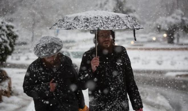
A rare snowstorm has hit Jerusalem area and parts of the occupied West Bank, choking off the city and stranding hundreds in vehicles on impassable roads.
Israeli authorities said at least 20 inches of snow had fallen since Thursday and more was forecast.

A rare snowstorm has hit Jerusalem area and parts of the occupied West Bank
“In my 54 years I don’t remember a sight like this, such an amount I cannot recall,” said Nir Barkat, mayor of Jerusalem.
The Israeli military helped police rescue hundreds of people stranded in vehicles on highways near the city.
[youtube 34k7s219aew 650]
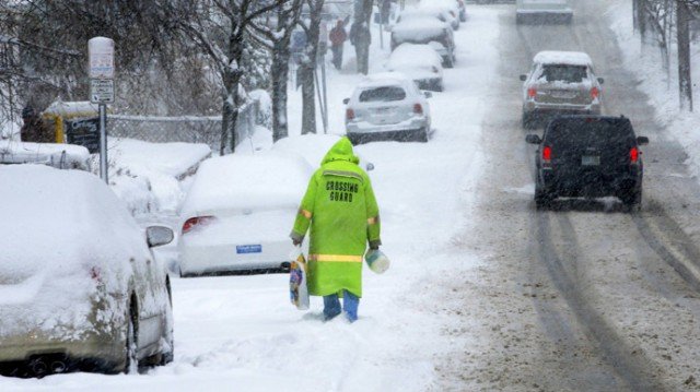
A winter storm that started in Washington has hit Texas hard on Saturday, causing event cancellations, travel hindrances and power outages.
Almost 50 weekend holiday events had been cancelled or postponed across Texas, including Sunday’s 44th annual Dallas Marathon, which was expected to draw 25,000 runners, many of whom had trained for months. The same weather system also forced the cancellation of the St. Jude Marathon in Memphis, which had been expected to include 20,000 competitors.
Four hundred flights remained grounded Sunday at Dallas Fort Worth International airport, according to airport officials, as crews scrambled to clear airport runways.
In Chicago, people started flooding into warming centers Saturday night as wind chills dropped below zero.
Some parts of Illinois were already slammed by a foot of snow, and Chicago would get 1 to 3 inches on Sunday, according to The Weather Channel.

A winter storm has hit Texas, causing event cancellations, travel hindrances and power outages
Residents in parts of Ohio, Kentucky and Tennessee also woke up to snow and ice on Sunday.
In Virginia, state Emergency Management spokeswoman Laura Southard said the storm had the potential to be an “historic ice event.”
Other areas of the US that could expect precipitation in the form of snow or freezing rain Sunday were the Middle Missouri Valley into the Great Lakes, the Ohio and Tennessee Valleys, the Mid Atlantic and southern New England, according to the National Weather Service (NWS).
Mississippi, the Central Gulf Coast and the Tennessee Valley were all expected to dodge snowfall but could experience heavy, cold rain, the NWS predicted.
Residents in New York, Philadelphia, Washington DC, and Baltimore were warned to be careful on the roads, as they could be hit by the first major snow accumulation of the season Sunday night. But the snow is expected to change to rain overnight, the Weather Channel reported, making the morning commute a messy one.
In the even colder areas of New England and upstate New York, even a slight snowfall could create Monday morning problems as it changes to freezing rain and slippery sheets of ice, according to The Weather Channel.
The storm is expected to move out to the Atlantic on Monday night, according to the NWS.
[youtube 4gl8hmH2Lrk 650]
Forecasters warned that an arctic blast will knock out power by coating parts of the South and Midwest with ice and send temperatures sinking by as much as 50 F Thursday.
The worst of the ice storm should stretch from Texas through Arkansas, the boot heel of Missouri and parts of Tennessee and Kentucky. Some places could get a half-inch or more of ice, enough to weigh down power lines and snap tree branches.
“Just prepare, plan and hunker down once this starts later tonight,” said Tom Niziol, an expert for The Weather Channel.
Kevin Roth, a lead meteorologist at the network, said that the region faced a “good 12 to 14 hours of freezing rain and ice” as an arctic air mass pushing south from Canada collides with moisture streaming up from the Gulf of Mexico.
Forecasters warned that an arctic blast will knock out power by coating parts of the South and Midwest with ice
The rough weather will be accompanied by jarring drops in the temperature. In Dallas, it was almost 80 F on Wednesday and will be in the 30s on Thursday night. In Lubbock, Texas, the high Tuesday was 77, and the forecast low for Friday night is 10.
A winter storm alert was posted for the Dallas area from 6 p.m. Thursday until 6 p.m. Friday.
Farther north and west, people faced extreme cold and snow. Temperatures could dip to minus 20 or worse in the northern midsection of the country, forecasters said. Snow totals could also approach 3 feet in northeastern Minnesota, where the weather has contributed to hundreds of traffic collisions around the state.
Colorado homeless shelters opened extra beds as temperatures in Denver were expected to drop just below zero through Friday but remain below 20 through the middle of next week. The storm dumped several inches of snow in Denver, and parts of Colorado’s mountains could get up to 3 feet by the end of the day.
Some Rocky Mountain ski resorts surpassed 100 inches of snow for the season on Wednesday.
Chicago could plunge from the mid-50s on Wednesday to the low teens by Friday night. Snow accumulations of 4 to 8 inches are possible from southern Missouri to northern Ohio through Friday night.
[youtube kTmrP026vro 650]
Heavy rain has lashed Cuba since Friday, flooding streets and leaving at least two people dead.
A number of buildings have collapsed in the capital, Havana, authorities say.
A 54-year-old man and a 60-year-old woman are reported to have died as a house crumbled in central Havana.
Up to 7.8in of rain fell overnight and the Cuban meteorological service has forecast more heavy rain for Saturday, particularly in the western and central regions.

Heavy rain has lashed Cuba since Friday, flooding streets and leaving at least two people dead
Yunior Amesa, the nephew of the two victims of the building collapse, told Associated Press news agency: “It was raining very hard and there was a lot of weight [from the water] up there. They went to bed.”
He says he narrowly escaped because he had to leave the house to go to work.
Many streets in Havana remain submerged, as the authorities assess the damage to other derelict buildings in the city.
Bad weather also led to the closure of the picturesque Malecon seaside boulevard, lashed by stormy waves, AP reported.
The torrential rain is expected to bring flooding to coastal areas in western Cuba and the central region.
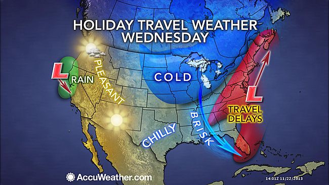
The winter storm blamed for up to a dozen deaths is threatening to bring travel misery to the East Coast on the eve of the Thanksgiving Day.
The system, which dumped heavy rain and snow over the region on Tuesday, has already caused some flight delays.
Forecasters say more than 1 ft of snow could fall in western Pennsylvania, western New York and Vermont before Thursday.
More than 43 million Americans are expected to travel during the holiday.
The storm is also threatening to ground the giant balloons at the Macy’s Thanksgiving Day Parade in New York.
City regulations bar the inflatables from being used when sustained winds exceed 23 mph or when gusts top 34 mph.
The balloons of beloved characters such as Mickey Mouse and the Pillsbury Doughboy are due to be made ready on Wednesday evening.
New York Governor Andrew Cuomo has issued a winter weather warning, urging motorists to use extreme caution.
Meteorologists also predict the storm could bring 2-4 in of rain up the Atlantic coast from Richmond, Virginia, to Portland, Maine.
The deadly winter storm is threatening to bring travel misery to the East Coast on the eve of the Thanksgiving Day
“It couldn’t have come at a worse time,” said meteorologist Tim Morrin, of the National Weather Service.
“Visibility will be restricted not only by the rain and wash from other cars, but from the fog.”
Late on Tuesday, flight delays were reported in Charlotte, North Carolina; Philadelphia, Pennsylvania; Memphis, Tennessee; and Baltimore, Maryland.
Daniel Baker, of flight-tracking service FlightAware, said that most airlines expect to continue operating full schedules, although further delays were likely.
Some travelers were getting on earlier flights to avoid ending up stranded.
Lisa Jablon was originally due to fly on Wednesday morning from New York City to Syracuse, New York state, but she moved her flight to Tuesday night.
“I’m flying up to spend the holiday with my boyfriend’s family and I didn’t want to get stuck,” she told the Associated Press news agency.
The icy weather started in the western states and has caused at least 10 fatal road crashes.
Deaths from weather-related accidents were reported in Oklahoma, Texas, New Mexico and California.
Thanksgiving Day celebrates the harvest and blessings of the past year.
It has been marked for hundreds of years, and is generally thought to commemorate a 1621 harvest feast the US Pilgrims shared with Indians after settling at Plymouth, in what is now Massachusetts.
The modern festival sees millions of people travel to be with family, eat turkey feasts, watch NFL football matches and – in recent years – plan or even begin their assault on the holiday sales.
[youtube Q8WoIlSlEnE 650]
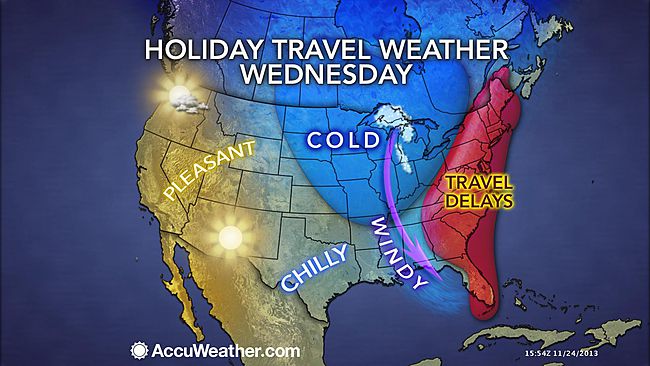
A deadly wintry storm heading toward East Coast threatens Thanksgiving travel plans for millions of Americans.
The storm threatens to dump snow on inland regions of several Northeast states on the eve of the holiday, a meteorologist said Monday.
The weather system has already heaped up to a foot of snow in the mountain regions of Utah and Colorado, and claimed 13 lives including a 4-year-old girl killed in a rollover smash on icy roads in New Mexico.

A deadly wintry storm heading toward East Coast threatens Thanksgiving travel plans for millions of Americans
With the storm gathering pace and moving northeast, the 43 million people who are expected to travel 50 miles or more for Thanksgiving were warned to avoid driving during the worst conditions slated for Tuesday and Wednesday, said Kevin Roth, lead meteorologist at The Weather Channel.
Three million of these travelers expected to fly, and there is also a good chance flights could be delayed leaving from airports in New York, Boston, Baltimore, and Washington D.C.
Kevin Roth said this was due to forecast low cloud and high wind, however, rather than ice or snow.
Some 300 flights were canceled at DFW International Airport across Saturday and Sunday, with officials there anticipating icy conditions.
[youtube ICPTUVPhx8U 650]
A wintry storm, which started in the Southwest on Thursday, could affect a good chunk of the country by the time its westward march comes to an end.
The storm making its way through New Mexico and Texas, with the possibility of advancing to the Northeast and hindering holiday travel plans along the way.
The inconveniently-timed storm will especially be a concern for the 43 million people who are expected to travel 50 miles or more for the Thanksgiving holiday, according to AAA.
Three million of those are slated to fly to their destinations, AAA predicted.
The “Nordic outbreak” will “produce a mixed bag of wily weather that will end up impacting much of the nation,” said National Weather Service meteorologist Joe Harris.
More than a foot of snow was reported on Sunday in many mountain regions of Utah and Colorado, but the greatest accumulation reached almost four feet in Abajo Peak in southeast Utah, according to the Weather Channel. Even Flagstaff, Ariz. has seen 6 inches of snow since the storm started Thursday night, according to AZ Central.
On Sunday, most of New Mexico and Texas and parts of Oklahoma were placed under National Weather Service winter storm warnings until Monday.
In New Mexico, forecasters predicted 5 inches of snow and temperatures as low as 20. The snow that began late Saturday, paired with the freezing temperatures, created dangerous driving conditions, and many roads were closed.
The icy roads there led to a rollover accident that killed a 4-year-old girl, State Police Sergeant Emmanuel Gutierrez said.

The inconveniently-timed storm will especially be a concern for the 43 million people who are expected to travel 50 miles or more for the Thanksgiving holiday
New Mexico NBC affiliate KOB reported strong winds and near white-out conditions late Saturday night along a stretch of I-40, about 80 miles west of Albuquerque.
On Saturday, a storm-related crash involving nearly a dozen vehicles left three dead in the Texas Panhandle.
Three more were killed due to the storm in California, where the storm first hit. A man was killed when he crashed his car into a tree and a woman was killed when a tree collapsed onto her parked car. A third person in California was found dead near power lines that were down due to heavy winds and flooding.
Additional flooding in Arizona swept a man into the Santa Cruz River. Firefighters recovered his body on Friday.
The wild weather system will spread east to Arkansas and northern Louisiana Sunday night into early Monday, according to the Weather Channel.
From there, it will most likely bring heavy rain to the Southeast through Tuesday, according to Weather Channel meteorologist Dr. Tom Niziol.
The storm is expected to dump rain on areas from Atlanta to the Carolinas on Monday and Tuesday then turn to snowfall over Tennessee through West Virginia as it continues to progress Northeast on Wednesday, Tom Niziol said.
Conditions in the Northeast were largely dry Sunday, but the region experienced a cold blast that bought temperatures down to 10 degrees overnight – conditions “considered cold by January standards,” according to the National Weather Service.
The region might see the second waves of the winter storm system on Wednesday, as many last minute travelers attempt to fly or drive long distances.
A blast of cold air from the north could merge with the storm system from the south and lead to snow accumulation in western and northern New England, Pennsylvania and New York, according to the Weather Channel.
In a second possibility, the two systems would not meet, but low pressure could produce snow in main northeast coastal cities.
Whether or not travelers make it to their destinations, the storm will have moved out to sea by Thanksgiving Day, allowing for dry conditions across most of the country, according to the Weather Channel.
Still, the Weather Channel predicts temperatures in the eastern part of the country will be 10 to 20 degrees below average on the holiday.
Thursday morning wind gusts between 20 and 30 mph in the Northeast could have the potential to damper the Macy’s Thanksgiving Day Parade in New York City, according to AccuWeather.com.
[youtube -lRIQOOPvRI 650]
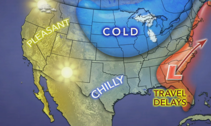
Thanksgiving travelers in the East and South on Tuesday and Wednesday will face trouble as a storm brings most areas rain but could also bring heavy snow to a narrow swath.
However, much of the rest of the nation will be dry.
The same storm affecting the Southwest with snow, ice, rain and thunderstorms this weekend will reach the Southeast with rain Tuesday. From there the storm will turn up the East Coast, tracking into colder air, perhaps causing even greater travel disruptions.
AccuWeather.com COO Evan Myers said: “If the storm hugs the coast and develops to its full potential, it could be a flight nightmare, not only for travelers in the East, but also throughout the nation.”
After drenching coastal Texas on Monday, the storm will cruise eastward along the Gulf coast Monday night and Tuesday.
Travel delays on the I-10 and I-20 corridors are in store from Louisiana to Mississippi, Alabama, Georgia and northern Florida from rain-soaked highways and poor visibility from downpours.
The rain can be heavy enough and cloud ceilings low enough to delay flights at New Orleans, Atlanta and other airports in the region.

Thanksgiving travelers in the East and South on Tuesday and Wednesday will face trouble as a storm brings most areas rain but could also bring heavy snow to a narrow swath
During Tuesday night, the drenching rain will begin to swing northeastward across South and North Carolina to Virginia, along the I-95 and I-85 corridors.
Right along the Gulf coast and over part of the southern Atlantic Seaboard, there is also the potential for strong to locally severe thunderstorms.
The exact track and intensity of the storm as it swings up or slips off the East Coast Tuesday night into Wednesday night are still in question and hold the key to dry weather versus rain versus snow in some locations.
Even if rain were to fall over much of the area, it would be enough to slow travel on the highways and delay a number of flights. Gusty winds would also factor in to delays along the coast, even if the storm were to roll out to sea.
Rain is the most likely form of precipitation from Virginia to near New York City then southeastern New England, with the air simply being too warm or the warm waters of the Atlantic Ocean exerting its influence. This includes Richmond, Virginia, Washington, D.C., Baltimore and Philadelphia.
If fresh cold air invades the storm, then there could be a period of snow over the mountains from northern West Virginia and western Maryland to central and northeastern Pennsylvania, upstate New York and western and northern New England. If this scenario pans out, major travel disruptions could be in store for portions of I-80, I-81, I-87, I-90 and I-91.
Only if the storm were to strengthen a great deal and draw more cold air in would there be a change from rain to snow in New York City, Hartford, Connecticut, and Boston.
For those traveling on Thanksgiving Day, the storm or its near-miss will likely have exited much of the region. However, some rain or snow is still possible early in the day in northern New England.
More details on the track of the storm and forecast for the Northeast will be released on AccuWeather.com as they becomes available.
A storm is forecast to move in from the Pacific Ocean during the middle of the week.
This storm will has a chance of bringing rain to the I-5 corridor in California to part of Oregon Wednesday into Thanksgiving Day.
As a result, there is a chance of wet weather and perhaps travel delays from San Francisco to Los Angeles. Some snow is possible in the Sierra Nevada and over Donner Pass along I-80.
Much of the rest of the nation will have good travel conditions.
Beware, aircraft and flight crews originating from the South and Northeast could be delayed, perhaps causing ripple-effect problems with a few flights throughout the nation.
There will be bands of lake-effect snow over the Upper Midwest, due to fresh cold air moving in Tuesday and Wednesday. The lake-effect snow should diminish in most locations by Thanksgiving Day.
[youtube -lRIQOOPvRI 650]
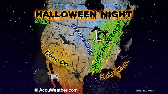
A massive storm system could make for a rainy Halloween for trick-or-treaters across the US from New England to Texas.
The ferocious storm system was hurtling from Texas to the northeast early Thursday, threatening to lash a long arm of the US with buckets of rain and high winds as officials in three states postponed trick-or-treating to Friday.
Meteorologists warned people in the Ohio Valley, the lower Mississippi Valley and western Gulf Coast to brace for harsh gusts of wind, hail and even tornadoes – a scary forecast just in time for Halloween revelry.
Trick-or-treating has been pushed to Friday in scores of cities in Indiana, Kentucky and Ohio – states expected to bear the brunt of the severe storm system, according to Weather.com.
The trouble was already brewing near Austin, Texas, early Thursday, where heavy train triggered flash floods, forcing scores of people from their homes amid evacuation advisories and prompting helicopter rescues, officials said.
Some areas surrounding the city were slammed by as much as 15 inches of rain, according to Austin-Travis County’s Emergency Medical Service (EMS). Meanwhile, emergency crews staged 15 water rescues across Austin and Travis counties throughout the early morning, EMS spokesman Warren Hassinger said.

A massive storm system could make for a rainy Halloween for trick-or-treaters across the US from New England to Texas
There was no reported deaths and only minor injuries early Thursday, although Warren Hassinger said there were reports from neighboring Hays and Comal Counties of people calling for help who were trapped in vehicles or clinging to trees.
The Texas Department for Public Safety said there were no firm numbers yet for the four worst affected counties of Williamson, Hays, Comel and Travis, but that there were at least 20 homes affected in Hutto, a town of more than 18,000 in Williamson County.
Austin Energy reported upwards of 12,000 customers without electric power Thursday morning, according to the Associated Press, while Wimberley Independent School District called off classes due to “extreme weather conditions,” according to its website. Schools in nearby San Marcos and Lockhart also cancelled classes amid the nasty weather and snarled traffic, the wire service reported.
The worst of the rain is over for the region, with the storm moving from west to east, according to the department.
“It will have hopefully abated by about 2 p.m. this afternoon,” a data collector at the department said.
“But the run-off is what we worry about – there’s always that danger.”
As the massive weather system barrels eastward, officials are warning people in the Midwest and Northeast to take precautions ahead of the storm.
The Indianapolis Department of Homeland Security announced Thursday that locals should stay away from big trees and clear their sidewalks so any flooding can cut a clear path.
Heavy rain may pound the Northeast on Friday, with high wind watches posted for the Great Lakes as well as areas of southern New England and Long Island, according to the National Wather Service.
Officials have warned coastal residents to brace for possible power outages as well as felled trees and power lines, according to Weather.com.
[youtube IWkFgGj-1JY 650]
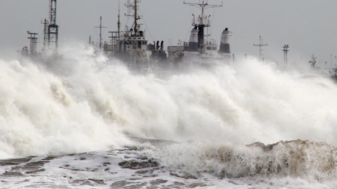
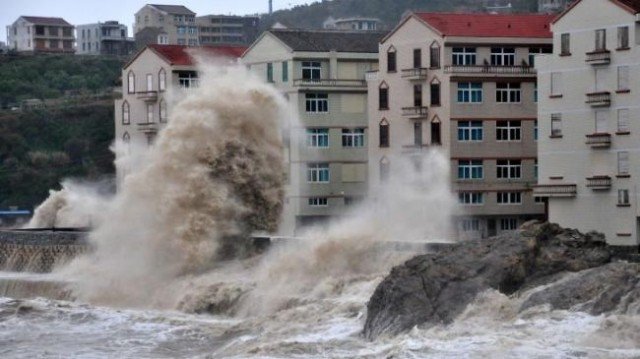
Around 140,000 homes are without power as St Jude storm continues to batter parts of England and Wales.
According to specialists, St Jude storm could be one of the worst storms since 1987.
Rail services across much of southern Britain have been cancelled for the morning rush hour.
The M4 Second Severn crossing has reopened but the M48 Severn Bridge is still closed, while 130 flights have been cancelled at Heathrow airport.
The Met Office said a gust of 99mph was recorded at Needles Old Battery, Isle of Wight, at 05:00 GMT.
The Environment Agency has issued 17 flood warnings – all in south-west England, there are also 152 flood alerts across England and Wales.

According to specialists, St Jude storm could be one of the worst storms since 1987
Tracy Elsey, from UK Power Networks, said 40,000 households were without power in its south-east region from Brighton to Kent – and 100,000 in its east of England region, from Essex to the north Norfolk coast.
“The power lines are hit by trees coming down in the wind and branches touching overhead lines and any other debris whipped up by the wind overnight,” she said.
Robin Gisby, network operations managing director for Network Rail, said more than 40 railway line blockages caused by falling trees have been cleared, but more are expected to be found by special trains being used to clear tracks.
He said: “In four cases the train being sent through to inspect the line has hit a fallen tree and we have one train in Devon which is currently disabled following a collision with a fallen tree. We are also dealing with a landslip in the New Forest area.”
Robin Gisby added: “As the storm passes from west to east, we will be carrying out safety assessments as quickly as possible to clear routes and get trains running safely.
“We now expect to start services into Waterloo before 09.00 GMT. Routes from Sussex, Kent and Anglia will follow. Services elsewhere into London are running but at reduced capacity and speed.”
[youtube Y0oaidQa7z4 650]
More than 400,000 people in India have been evacuated as Cyclone Phailin sweeps through the Bay of Bengal towards the east coast.
Cyclone Phailin, categorized as “very severe” by weather forecasters, is expected to hit Orissa and Andhra Pradesh states on Saturday evening.
The Meteorological Department has predicted the storm will bring winds up to 136 mph.
A deadly super-cyclone in 1999 killed more than 10,000 people in Orissa.
However, the US Navy’s Joint Typhoon Warning Center in Hawaii is forecasting even stronger winds, predicting sustained speeds of up to 167 mph.
Officials said Cyclone Phailin is expected to make landfall close to the city of Gopalpur (Orissa state), bringing a storm surge of at least 10 ft that was likely to cause “extensive damage” to mud houses on the coast.

More than 400,000 people in India have been evacuated as Cyclone Phailin sweeps through the Bay of Bengal towards the east coast
“No-one will be allowed to stay in mud and thatched houses in the coastal areas,” said Orissa’s Disaster Management Minister Surya Narayan Patra.
The army is on standby in the two states for emergency and relief operations. Officials said helicopters and food packages were ready to be dropped in the storm-affected areas.
Meanwhile, the US Navy’s Joint Typhoon Warning Centre predicted that Phailin could produce gusts of up to 315 km/h, while the London-based Tropical Storm Risk classified Phailin as a Category Five storm – the most powerful.
The Times of India newspaper warned that local meteorologists may be underestimating the severity of the storm.
Meteorologists also say that the storm is not only intense but covers a wide area.
Fishermen have been asked not to venture out to sea.
Rain and winds are already being felt in Orissa, where authorities said they were setting up shelters for people who would need to be evacuated.
“We are fighting against nature. We are better prepared this time, we learnt a lot from 1999,” said Surya Narayan Patra.
Reports said that there had been panic buying in the state capital, Bhubaneswar, with shelves being emptied of food.
“I’m feeling scared and tense. My son is expected to arrive Sunday. Now I think he won’t make it,” housewife Manjushree Das told the Agence France-Presse news agency.
India’s eastern coast and Bangladesh are routinely hit by cyclonic storms between April and November which cause deaths and widespread damage to property.
In December 2011, Cyclone Thane hit the southern state of Tamil Nadu, killing dozens of people.
[youtube dcJ1CwTGa7k]
Typhoon Fitow has hit eastern China after triggering the evacuation of hundreds of thousands of people.
With winds up to 93mph, the storm landed in Fujian province early on Monday, bringing heavy rains and causing widespread power cuts.
At least two people have been killed by the typhoon, state-run news agency Xinhua reported.
The authorities earlier issued the highest alert – red – for the area.
Some homes are said to have collapsed in neighboring Zhejiang province and two port workers are missing.
Typhoon Fitow – named after a flower – made landfall at 01:15 local time on Monday in the city of Fuding, Chinese meteorologists said.
Typhoon Fitow has hit eastern China after triggering the evacuation of hundreds of thousands of people
They warned that some areas in Fujian and Zhejiang could see more than 8 inches of rain in the coming hours.
In Fujian, 177,000 people were evacuated before the storm hit the coast, Xinhua said, while in Zhejiang, some 574,000 people had to leave their homes.
Some 35,000 boats in Zhejiang and 30,000 in Fujian were ordered to return to harbor for shelter.
Coastal facilities such as seaside bathing centres were also closed, state media reported.
“We must not leave anybody in danger,” Zhejiang Governor Li Qiang was quoted as saying.
The typhoon also caused suspension of bullet trains and coach services in several cities in the area.
Dozens of flights to and from Wenzhou airport in Zhejiang were cancelled.
The storm is now moving north-west and is expected to weaken quickly.
Typhoon Fitow is the 23rd typhoon to hit China this year, Xinhua reported.
It comes just weeks after Typhoon Usagi killed at least 25 people in southern Guangdong province.
[youtube waZ0AC0EIkk]
As the East Coast is still reeling from the devastation brought on by Superstorm Sandy forecasters are already warning of a powerful new nor’easter storm front coming in from the Atlantic, bringing 45 mph gusts of wind mixed with snow and rain.
The beleaguered coast line is expected to face the storm from Tuesday to Thursday – potentially casting a shadow over Election Day.
At least New York City and the surrounding area may escape a beating, as forecasters expect most of the severe weather will hit northern New England – meaning it should land hundreds of miles north from where Sandy reached the continent.
However, New York and New Jersey can expect frigid winds and rain as hundreds of thousands remain without power and homeless.
A nor’easter is a powerful storm that thrives on cold air. Severe nor’easters can bring hurricane-force winds and blizzards.
AccuWeather expert senior meteorologist Henry Margusity said: “For millions of people still recovering from Superstorm Sandy, this is not welcome news.
“Thousands are projected to still be in the dark on Election Day, following Sandy’s impact.
“The weather pattern remains volatile for another storm to form on the East Coast, but nothing like Sandy. A storm that would be more normal for early November.”
Meanwhile, NBC News meteorologist Al Roker said: “This is just what we don’t need.
“You look at those winds coming counterclockwise, bringing in with it the potential for one to two more inches of rain, wind gusts of 45 miles per hour and wet snow inland just along the New York/New Jersey border. We’re talking about wet snow mixing in.
“The problem with this, with these winds of 45 miles per hour and already compromised beaches along New Jersey and Long Island waves of any consequence could cause big problems.”
He added: “It’s just a matter of how strong this system is going to be.”

East Coast line is expected to face a nor’easter winter storm from Tuesday to Thursday, potentially casting a shadow over Election Day
The European Centre Medium Range Forecast predicted the storm will form off the coast of Georgia and South Carolina on Tuesday.
EURO detected Hurricane Sandy and predicted its devastating landfall 8 days before it hit.
By Wednesday, the storm is expected to hook into southern New England.
Forecasters said that the storm will have nowhere near the strength of Sandy and the winds will likely not be powerful enough to be damaging.
However, the storm will bring more rain and bad weather to a region that has not even begun to recover from Monday’s onslaught.
“Snowfall would be confined to northern New England. Also, this system will not be anywhere as impactful as Sandy,” Tom Niziol, the winter weather expert for Weather.com, wrote.
Forecasters still don’t know the exact impact or path of the storm, and cautioned that it could hit other parts of the coast – potentially even New York.
Consolidated Edison, which handles New York City and the Hudson Valley, still has 650,000 customers without power – and said many of them won’t have electricity restored for another ten days.
Two of New Jersey’s largest utility companies reported more than 2million customers still in the dark.
What is a nor’easter?
The nor’easter is a winter storm conceived by the meeting of cold arctic air with the warmer ocean air from the Gulf Stream.
The storms usually develop from a low-pressure system in the south, typically in the Gulf of Mexico, and then pushed upward.
They often cause severe flooding along coastlines, erosion, and blizzard conditions – but just as dangerous is the bitter Arctic air that gets dragged along by the weather system.
They storms can come at any time of year, but are mainly seen in winter, where the conflicting wind conditions can quickly spiral into a hurricane.
Nor’easters usually bring massive amounts of precipitation, high winds and large waves and with a full moon, when tides are at their highest, the storm surge could reach as high as 6 to 11 feet.
“The total is greater than the sum of the individual parts,” said Louis Uccellini, the environmental prediction chief of the National Oceanic and Atmospheric Administration meteorologists about the dramatic weather.
[youtube GnBnOijTMlU]
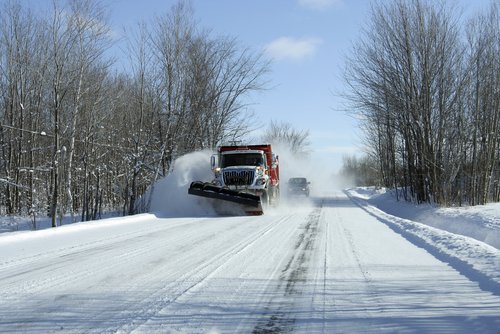
Parts of New Mexico, Texas, Oklahoma, Kansas and Colorado will encounter heavy snow and high winds bringing a nasty blizzard starting with today until Wednesday.
Weather forecasters warn interstate highways and local roads will make driving treacherous, or even impossible, snarling holiday travel plans the days before Christmas.
Up to 18 inches of snow is expected in northeastern New Mexico, the Oklahoma and Texas panhandles, southwestern Kansas and southeastern Colorado, which were under blizzard watches or warnings today through Wednesday.
Meteorologist Kerry Jones in Albuquerque, New Mexico is warning people in the region not to be fooled by today’s pleasant weather – the storm is expected to move in quickly and is potentially life-threatening.
“Those are tremendous amounts of snow,” Kerry Jones said.
“Add to that the fact that that snow is going to be blowing, and you’re going to have winds easily in the 40 mph range if not higher, it’s going to be a very ugly, potentially life-threatening situation.
“We try to reserve these blizzard watches for very intense storm systems.”
Much of Kansas will be affected, with the heaviest snowfall from southwestern Kansas, south into the Oklahoma panhandle, south toward Amarillo, Texas, and west into the New Mexico plains.
The intense low-pressure system was circulating south of Yuma, Arizona, today, but was expected to move into southwestern New Mexico overnight.

Much of Kansas will be affected, with the heaviest snowfall from southwestern Kansas, south into the Oklahoma panhandle, south toward Amarillo, Texas, and west into the New Mexico plains
Rain will develop first, but the system is expected to intensify and turn colder, with snow expected in Albuquerque and Santa Fe, New Mexico, by midday. Up to four inches could fall in the foothills around Albuquerque, and Santa Fe could get up to five inches.
Much heavier snow is expected as the storm moves to the northeast along the Great Divide and into the plains, where winds above 40 mph may create near white-out conditions along highways. Clayton, New Mexico, near the Texas-Oklahoma line, could see the most snow it’s measured in five years, estimated at 15 inches or more. One area outside Amarillo could get up to 18 inches.
There is a 90% chance that Interstate 40 in eastern New Mexico will be closed because of low visibility and blowing snow by late tomorrow afternoon.
Livestock could be affected, so ranchers in the region should take precautions to protect their cattle.
The storm is a fast-mover and is expected to leave the region by midday Tuesday. But temperatures will stay in the 20s and 30s so the snow won’t melt quickly, and a weaker storm that could move into New Mexico Tuesday will likely follow the same general track.
 Prev12Page 2 of 2