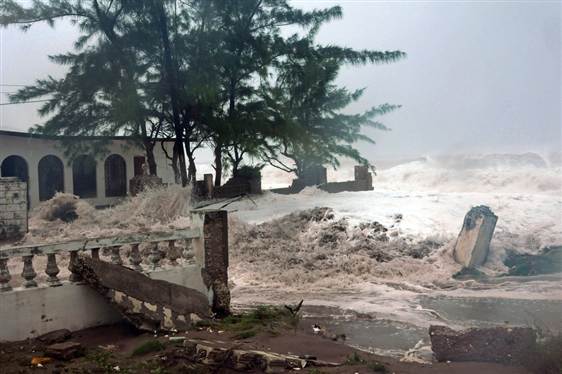
Hurricane Sandy, which left 21 people dead as it barreled through the Caribbean, could likely metamorphose into frightening storm that could cause $1 billion in damages.
Experts say the tempest – dubbed Frankenstorm – has a 90% chance of hitting the East Coast of the U.S., having the potential to wreak havoc with heavy winds, rain, flooding, and downed trees and power lines.
In fact, longtime weatherman Chad Myers, who works for the NOAA, wrote: “After 26 years in TV weather and two years with NOAA, Sandy may pose the greatest risk to human life that I have seen.”
The projected course of Hurricane Sandy is difficult to guess at this time, though.
Experts from the Weather Channel are cautioning residents in the eastern states, including North Carolina, New York, New Jersey, Pennsylvania, Delaware, Maryland, and Virginia.
Residents in coastal areas are advised to take precaution as the deadly storm barrels its way up the U.S. shoreline. Early forecasting by NOAA reveals that the storm could hit somewhere between Pennsylvania and Long Island, putting central New Jersey at the greatest risk thus far.
Those in the tri-state area are no strangers to deadly super storm threats. Only last year, Hurricane Irene ploughed through the greater New York City area, causing extensive damage. However, the overall impact was less than expected.
The Frankenstorm could also deposit snowfall as far south as North Carolina, according to The Wall Street Journal’s Metropolis blog.
Government meteorologists are giving the storm a 70% chance of hitting land next week, ruining Halloween celebrations for millions of children who have dressed up for trick or treating door knocks.
“The potential is there,” said National Weather Service scientist Charlie Foley.
The horrific storm could happen if Hurricane Sandy in the Caribbean, an early winter storm in the West, and a blast of arctic air from the North collide, sloshing and parking over the country’s most populous coastal corridor starting Sunday.
The worst of it should peak early Tuesday, but it will stretch into midweek, forecasters say.
“It’ll be a rough couple days from Hatteras up to Cape Cod,” said forecaster Jim Cisco of the National Oceanic and Atmospheric Administration (NOAA) prediction center in College Park, Maryland.
“We don’t have many modern precedents for what the models are suggesting.”
It is likely to hit during a full moon when tides are near their highest, increasing coastal flooding potential, NOAA forecasts warn. And with some trees still leafy and the potential for snow, power outages could last to Election Day, some meteorologists fear. They say it has all the earmarks of a billion-dollar storm.
Currently, Hurricane Sandy is moving through the Caribbean with high winds and heavy rain.
It made landfall in southeastern Jamaica yesterday with a wind speed of 80 mph and has already been responsible for the death of one person in Haiti and two in Jamaica.
Some have compared it to the so-called Perfect Storm that struck off the coast of New England in 1991, but Jim Cisco said that one didn’t hit as populated an area and is not comparable to what the East Coast may be facing. Nor is it like last year’s Halloween storm, which was merely an early snowstorm in the Northeast.
Multiple elements must come together for Hurricane Sandy to become a repeat or match the Perfect Storm of 1991.
The worst-case scenario occurs as Sandy, in the form of a Category 1 hurricane or hybrid storm traveling north to be captured by chilly air coming down from Canada to be met by strong high level winds off the North Atlantic coast.
This nightmare outcome is referred to by meteorologists as an atmospheric “bomb” according to Accuweather.
Fearing this, people from North Carolina to Maine and Nova Scotia have been told to keep watching weather forecasts in case the Halloween storm does hit with full force.
This has much more mess potential because it is a combination of different storm types that could produce a real whopper of weather problems, meteorologists say.
“The Perfect Storm only did $200 million of damage and I’m thinking a billion,” said Jeff Masters, meteorology director of the private service Weather Underground.
“Yeah, it will be worse.”
But this is several days in advance, when weather forecasts are far less accurate. The National Hurricane Center only predicts five days in advance, and on Wednesday their forecasts had what’s left of Sandy off the North Carolina coast on Monday.
But the hurricane center’s chief hurricane specialist, James Franklin, said the threat keeps increasing for a major impact in the Northeast, New York area.
“In fact it would be such a big storm that it would affect all of the Northeast.”
Late Thursday, the hurricane’s center was about 185 miles (300 kilometers) east-southeast of Freeport, Bahamas. The storm had maximum sustained winds of 90 mph (150 km/h) and was moving north-northwest at 13 mph (20 km/h).
Sandy, which crossed Cuba and reached the Bahamas as a category 2 hurricane, was expected to maintain its category 1 storm status for the next several days.
[youtube -IUZSrjF664]