
TEHRAN/JERUSALEM — The face of the Middle East has been violently redrawn.
“Operation Epic Fury,” the joint U.S.-Israeli air campaign launched in the early hours of Saturday, February 28, was not merely a singular “decapitation strike” against Ayatollah Ali Khamenei. It was a massive, multi-front assault designed to paralyze Iran’s command-and-control, obliterate its key nuclear facilities, and trigger the collapse of the Islamic Revolutionary Guard Corps (IRGC).
Using exclusively obtained satellite imagery, geospatial data from open-source intelligence (OSINT) monitors, and official briefings, this report maps the geometry of the most significant military action in the region since the 1979 Revolution.
Map 1: The Three-Wave Incursion (01:30–05:00 LT)
The operation utilized a complex, phased approach designed to first “blind” Iranian defenses before striking high-value targets.
- The Ingress: The initial wave focused on neutralizing Iran’s long-range radar systems and Russian-supplied S-300 air defense batteries located near the borders. This created a “sanctified corridor” through which subsequent waves of attack aircraft could pass with relative impunity.
- The Tools: OSINT monitors detected an intense electronic warfare (EW) surge emanating from U.S. and Israeli assets in the Persian Gulf and the Eastern Mediterranean, designed to jam Iranian communications and missile guidance systems.
- The Routes: Strike packages—including American B-2 stealth bombers and Israeli F-35I ‘Adir’ fighters—utilized at least three distinct ingress routes, including a daring corridor through Iraqi airspace that had been quietly cleared with Baghdad.
(Visual Concept: A map of the Middle East showing arcs of incursion from U.S. bases in the Gulf (Qatar, UAE, Bahrain) and Israeli airbases, converging on Iran from the west, south, and southwest. A separate overlay shows the locations of jammed S-300 batteries in western Iran.)
Map 2: Ground Zero — The Tehran Decapitation
The defining image of “Epic Fury” is the destruction of the Supreme Leader’s secure compound in the heart of Tehran. This map provides a block-by-block breakdown of the critical 02:15 LT strike.
- Target Alpha: The primary residence of Ayatollah Khamenei. Satellite imagery reveals the structure was struck by at least two BLU-109 “bunker-buster” munitions, collapsing the secure underground levels where the leadership was believed to be taking cover.
- Collateral Damage: The map details the proximity of the strike to civilian infrastructure, including the Tehran Medical University and several residential blocks. Emergency services reported over 200 deaths in the capital alone, fueling accusations of disproportionate force from critics.
- IRGC HQ: A simultaneous strike targeted the IRGC’s Central Command Center nearby, which monitors and geolocates footage confirmed was left in a state of chaotic ruin.
(Visual Concept: A high-resolution urban map of central Tehran with a 1km blast radius overlay centered on the Supreme Leader’s compound. Key government and military buildings are highlighted in red; civilian infrastructure like hospitals and schools are marked in blue.)
Map 3: Obscuring the Atom — The Nuclear Sites
While the decapitation strike captured the headlines, the long-term strategic objective was the neutralization of Iran’s nuclear program. This map illustrates the precision strikes on key enrichment and development facilities.
- Fordow Fuel Enrichment Plant: This deep-mountain facility, long considered “bomb-proof” by Tehran, was targeted by American B-2 bombers utilizing the GBU-57 Massive Ordnance Penetrator (MOP). Satellite analysis confirms at least one direct hit on the main entrance tunnel, causing a “significant collapse” and sealing the centrifuge hall.
- Natanz: Both the surface-level Fuel Enrichment Plant (FEP) and the Pilot Fuel Enrichment Plant (PFEP) suffered catastrophic damage. Geolocation data confirms that Israeli stealth fighters specifically targeted the power substations, crippling the power-intensive enrichment process.
- Esfahan: The Uranium Conversion Facility (UCF), critical for creating the precursor for enrichment, was also hit in the first wave.
(Visual Concept: A topographical map of central Iran, highlighting Fordow, Natanz, and Esfahan. For Fordow, an illustrative cutaway view shows how a ‘bunker-buster’ weapon could penetrate the mountain facility. A timeline graphic below tracks the sequential strikes on each site.)
The Day After: The Fallout Map
As of Sunday morning, the Middle East is in a state of chaotic transition. This final map visualizes the immediate fallout of “Epic Fury.”
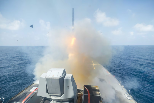
- The Counter-Barrage: Iran’s retaliatory launch of hundreds of drones and missiles is mapped, showing flight paths aimed at Tel Aviv, Haifa, and U.S. bases in the Gulf.
- The Maritime Crisis: A warning zone is overlayed across the Strait of Hormuz, reflecting the IRGC Navy’s stated threat to close the world’s most critical oil chokepoint.
- The Refugee Surge: Intelligence assessments are already mapping a surge of civilians fleeing Tehran and other target cities toward the Turkish and Iraqi borders, signaling the potential start of a massive humanitarian crisis.
(Visual Concept: A dynamic map of the entire region. Retaliatory missile flight paths are shown in red; a shaded ‘conflict zone’ covers the Strait of Hormuz and surrounding waters. Arrows along the land borders indicate emerging refugee flows.)
“Operation Epic Fury” has been executed. The maps confirm that the architectural foundations of the Islamic Republic’s military and nuclear power have been decimated. The only map yet to be drawn is the one that shows what takes its place.