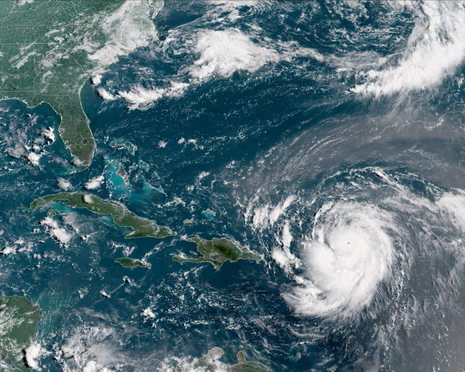
In a terrifying display of nature’s fury, Hurricane Erin has undergone an “incredible” rapid intensification, rocketing from a tropical storm to a catastrophic Category 5 hurricane in just 24 hours, the National Hurricane Center (NHC) announced today. The first Atlantic hurricane of the 2025 season, Erin is now churning through the Caribbean with maximum sustained winds of 160 mph, putting nearby islands on high alert for life-threatening flooding and rip currents.
The explosive growth has shocked even seasoned meteorologists. “Erin gained strength at a pace that was incredible for any time of year, let alone August 16th,” said hurricane specialist and storm surge expert Michael Lowry. The storm’s swift evolution is a stark reminder of the increasing frequency of rapid intensification events, which scientists say are fueled by exceptionally warm ocean temperatures in the Atlantic basin.

As of the latest advisory, the core of Hurricane Erin is located about 105 miles north of Anguilla and is moving west. While the NHC forecasts the storm’s center will remain over open water and swerve north of Puerto Rico and the Virgin Islands, its sheer power and growing size mean that nearby islands are not in the clear. Tropical storm watches have been issued for St. Martin, St. Barts, and St. Maarten, and officials are warning of heavy rain that could trigger flash flooding, landslides, and mudslides.
The outer bands of the storm are already lashing the U.S. Virgin Islands and Puerto Rico, where authorities are taking extensive precautions. The U.S. government has deployed over 200 Federal Emergency Management Agency (FEMA) employees to Puerto Rico, and officials have closed seaports and inspected hundreds of shelters.
While a direct landfall on the U.S. mainland is not expected, the storm’s influence will be far-reaching. The NHC predicts that Erin will at least double or even triple in size in the coming days, generating powerful swells that will create life-threatening rip currents along the U.S. East Coast from Florida to the mid-Atlantic next week.
Erin’s formation and rapid strengthening mark a dramatic start to what forecasters have predicted will be an unusually active hurricane season. The storm is a powerful and sobering reminder that in a warming world, the rules of the game are changing, and a “perfect storm” can form with unprecedented speed. For now, the focus remains on the Caribbean, where residents are bracing for the impacts of a compact but “catastrophic” storm that has become a monster overnight.