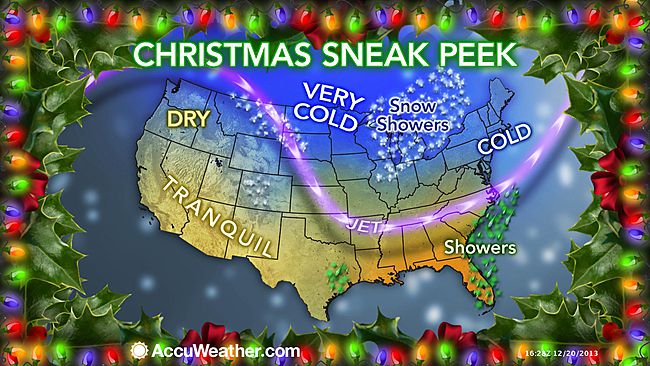
The worst weather will focus on the days prior to Christmas as millions of travelers take to the roads and skies in the US and southern Canada.
According to AAA, 94.5 million people will travel 50 miles or more over the holiday season, spanning December 21st to January 1st.
Most of the travel troubles will be caused by a single storm system forecast to affect much of the Central and Eastern states on Saturday and Sunday.
The storm this weekend will bring a wide variety of weather ranging from temperature extremes to heavy snow, ice, flooding rain, fog, severe thunderstorms and the potential for tornadoes. Major airport hubs from Dallas to St. Louis, Detroit, Atlanta, Chicago, Boston and New York City.
Another dose of snow will sweep inland over the Northwest to the northern Rockies on Monday.
The main storm this weekend will begin to put down snow across the northern Texas Panhandle and western Oklahoma on Saturday.

As the storm rolls out, heavy snow will develop later Saturday over central Kansas and will continue along a northeasterly path Saturday night and Sunday through northwestern Missouri, central and southeastern Iowa and Wisconsin, much of northern Michigan and across central Ontario, southern Quebec and northern New Brunswick.
Portions of the central Plains, Upper Midwest and southeastern Canada could be on the receiving end of a foot (30 cm) of snow. Ice and a wintry mix is also another concern for travelers with the storm from part of central Oklahoma to southern Michigan, southern Ontario, along the St. Lawrence River in Ontario, northern upstate New York, northern New England central and southern New Brunswick. Enough ice can accumulate in part of this area to bring down trees and power lines.
The snow and ice could bring vehicles to a crawl or possibly shut down portions of I-29, I-35, I-70, I-80 and I-90 in the US, and highways 2, 20, 40 and 401 in Canada.
On the southeastern flank of the storm from central and coastal Texas to southern New England, drenching rain will fall. Some of the rain will be heavy enough to cause flooding.
Episodes of dense fog could also be a player in slowing ground travel and causing flight delays, especially from around the Great Lakes to the Northeast.
Farther south, there is the risk of damaging thunderstorms and tornadoes from parts of central Texas to the southern tip of Indiana Saturday and Saturday night, with the risk of locally severe thunderstorms farther east on Sunday.
A cold front associated with the storm system will push showers and thunderstorms to the Atlantic Seaboard late in the weekend. Downpours, poor visibility and locally gusty winds could cause travel delays during this time from Boston to New York City, Philadelphia, Washington, D.C., Charlotte and Atlanta Sunday afternoon and evening.
Until then, much of the area will bask in record-challenging warmth. Prior to downpours late in the weekend, fog could be a problem for a time from Philadelphia to New York City and Boston Saturday. Gusty winds could be an issue at some airports in the Northeast on Sunday.
