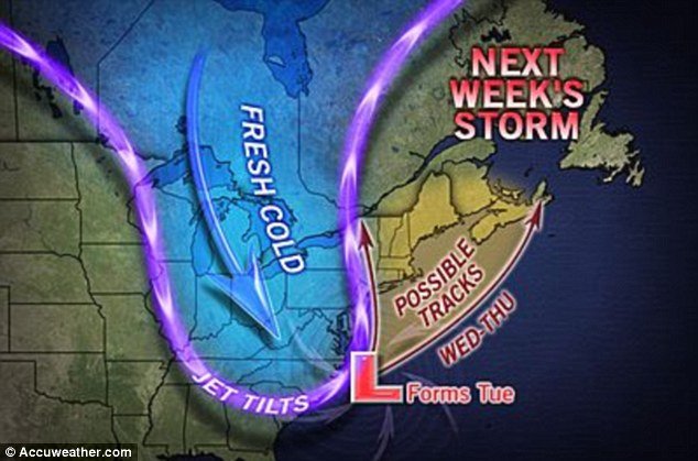
As the East Coast is still reeling from the devastation brought on by Superstorm Sandy forecasters are already warning of a powerful new nor’easter storm front coming in from the Atlantic, bringing 45 mph gusts of wind mixed with snow and rain.
The beleaguered coast line is expected to face the storm from Tuesday to Thursday – potentially casting a shadow over Election Day.
At least New York City and the surrounding area may escape a beating, as forecasters expect most of the severe weather will hit northern New England – meaning it should land hundreds of miles north from where Sandy reached the continent.
However, New York and New Jersey can expect frigid winds and rain as hundreds of thousands remain without power and homeless.
A nor’easter is a powerful storm that thrives on cold air. Severe nor’easters can bring hurricane-force winds and blizzards.
AccuWeather expert senior meteorologist Henry Margusity said: “For millions of people still recovering from Superstorm Sandy, this is not welcome news.
“Thousands are projected to still be in the dark on Election Day, following Sandy’s impact.
“The weather pattern remains volatile for another storm to form on the East Coast, but nothing like Sandy. A storm that would be more normal for early November.”
Meanwhile, NBC News meteorologist Al Roker said: “This is just what we don’t need.
“You look at those winds coming counterclockwise, bringing in with it the potential for one to two more inches of rain, wind gusts of 45 miles per hour and wet snow inland just along the New York/New Jersey border. We’re talking about wet snow mixing in.
“The problem with this, with these winds of 45 miles per hour and already compromised beaches along New Jersey and Long Island waves of any consequence could cause big problems.”
He added: “It’s just a matter of how strong this system is going to be.”

The European Centre Medium Range Forecast predicted the storm will form off the coast of Georgia and South Carolina on Tuesday.
EURO detected Hurricane Sandy and predicted its devastating landfall 8 days before it hit.
By Wednesday, the storm is expected to hook into southern New England.
Forecasters said that the storm will have nowhere near the strength of Sandy and the winds will likely not be powerful enough to be damaging.
However, the storm will bring more rain and bad weather to a region that has not even begun to recover from Monday’s onslaught.
“Snowfall would be confined to northern New England. Also, this system will not be anywhere as impactful as Sandy,” Tom Niziol, the winter weather expert for Weather.com, wrote.
Forecasters still don’t know the exact impact or path of the storm, and cautioned that it could hit other parts of the coast – potentially even New York.
Consolidated Edison, which handles New York City and the Hudson Valley, still has 650,000 customers without power – and said many of them won’t have electricity restored for another ten days.
Two of New Jersey’s largest utility companies reported more than 2million customers still in the dark.
What is a nor’easter?
The nor’easter is a winter storm conceived by the meeting of cold arctic air with the warmer ocean air from the Gulf Stream.
The storms usually develop from a low-pressure system in the south, typically in the Gulf of Mexico, and then pushed upward.
They often cause severe flooding along coastlines, erosion, and blizzard conditions – but just as dangerous is the bitter Arctic air that gets dragged along by the weather system.
They storms can come at any time of year, but are mainly seen in winter, where the conflicting wind conditions can quickly spiral into a hurricane.
Nor’easters usually bring massive amounts of precipitation, high winds and large waves and with a full moon, when tides are at their highest, the storm surge could reach as high as 6 to 11 feet.
“The total is greater than the sum of the individual parts,” said Louis Uccellini, the environmental prediction chief of the National Oceanic and Atmospheric Administration meteorologists about the dramatic weather.
[youtube GnBnOijTMlU]